HABCAST
Welcome To HABCAST
HABCAST, Harmful Algal Bloom Collaboration to Advance Stakeholder Tools, is a community of practice (CoP) that works to engage, share issues of concern, synthesize information, build expertise, acquire and develop new tools and products, and more fully integrate HAB outreach within Sea Grant and partner networks.
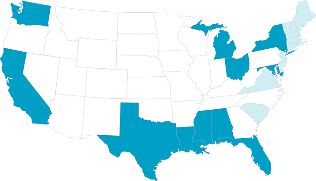
HABCAST is a network of people to facilitate data acquisition, synthesis, and the transfer of technology and knowledge.
Harmful algal blooms (HABs) have been reported to occur in the surface waters of all 50 U.S. states and are increasing globally. HABs occur when photosynthetic algae that live in fresh, brackish or marine waters grow out of control (i.e., “bloom”) and have adverse effects on people or ecosystems.
These HABs can result in significant socioeconomic impacts due to shellfish closures, wild or farmed fish mortalities, human health impacts, lost coastal recreation and tourism, reduced waterfront property values, and consumers who avoid consuming seafood. As a result, HABs are not only compromising the health of our coastal ecosystems, but they are also affecting the resiliency of our communities and economies. Early detection can mitigate some of the harmful effects of HABs, thus reducing associated socioeconomic impacts.
Why A Community of Practice?
Communities of practice (CoP) are formed by people who engage in a process of collective learning in a shared domain. Benefits of a HABCAST CoP to project partners and the larger national network include:
- A mechanism for engagement on the development of decision-making tools is provided.
- Capacity around satellite data use via value-added training is increased.
- Ideas and lessons learned are shared.
- Integrated, user-friendly HAB forecast services are delivered to a broad range of coastal stakeholders.
- Research gaps are identified and filled, thus moving more states/regions towards more reliable and accurate forecasting models.
- HAB products and decision support tools across the Sea Grant network are enhanced.
About The NOAA HAB Liaison
HABCAST is led by NOAA HAB Liaison Betty Staugler. Housed within Florida Sea Grant, Staugler forges and enhances partnerships by providing expertise, research, and extension services that leverage partners’ work to efficiently meet the needs of coastal and Great Lakes communities threatened by harmful algal blooms (HAB). This includes seeking new ways to extend NOAA HAB products and services, while also informing NCCOS, CoastWatch, and IOOS on Sea Grant stakeholder needs and research priorities.

Working Together
HABCAST
Network
By working together and through a national liaison, HABCAST establishes and maintains a network of people to facilitate data acquisition, synthesis, and the transfer of technology and knowledge.
Upcoming Workshops & Trainings
HAB Tools By Location
The following tabs contain links to existing monitoring and forecasting tools available nationally and in coastal regions and states. Tools include:
- Real-time daily and multi-day imagery
- Forecasts and warnings of HAB extent, trajectory and toxicity
- Scenario-based predictive models
- Monitoring and observations systems that support forecasts
More coming soon!
| Agency | Tool | Description | |
|---|---|---|---|
| NOAA NCCOS | Real-time satellite products for use in locating, monitoring and quantifying algal blooms in coastal and lake regions of the US | ||
| CoastWatch | Value-added data provider that offers a range of services centered on satellite product development, data distribution and user capacity building, tool development and sometimes direct collaboration on projects and applications. | ||
| EPA | Easy-to-use, customizable mobile app that provides access to cyanobacterial bloom satellite data for over 2,000 of the largest lakes and reservoirs across the United States. | ||
| WHOI | Serves as a “clearinghouse” for information related to national and international activities on HAB issues, including lists of opportunities to participate in volunteer HAB monitoring across the U.S. |
| State/Region | Agency | Tool | Description |
|---|---|---|---|
| Pennsylvania | Regional Science Consortium | The Regional Science Consortium monitors a variety of algal concentrations in real-time between May and October. | |
| Erie County Department of Health | Map shows results of routine water tests, swimming advisories, warning about Harmful Algal Blooms, and is updated regularly from late May to end of October. | ||
| GLOS | Provide real-time data to characterize the presence and toxicity of HABS and contribute to the development of an early warning system |
| State/Region | Agency | Tool | Description |
|---|---|---|---|
| Northeast | NERACOOS | NERACOOS has multiple data products that includes real-time buoy map, historical data, ocean climate, sea surface temperature, and high-frequency radar. | |
| Mid-Atlantic | MARACOOS | Visualization tool integrating near real-time observational assets and model forecasts that contribute to ocean monitoring in the Mid-Atlantic region. | |
| Southeast | SECOORA | A data exploration tool with a customized public web interface that allows scientists, managers, and the general public to discover and access public data. | |
| Rhode Island | University of Rhode Island | One of the world’s longest-running plankton surveys. Since 1957, weekly samples are collected to assess the phytoplankton community and characterize physical parameters of Narragansett Bay. | |
| Virginia | VIMS | Tools predict current status of important environmental variables and how they are likely to change in the short-term. |
| State/Region | Agency | Tool | Description |
|---|---|---|---|
| Gulf of America | NOAA | NCCOS monitors conditions daily and issues regular forecasts for red tide blooms in the Gulf of America and East Coast of Florida | |
| NOAA | A tool for environmental managers, scientists, and the public to track and observe current and historical harmful algal bloom events in the Gulf of Mexico | ||
| GCOOS | A beach-level risk forecast activated during red tide conditions to inform beachgoers what impacts are expected to be at the beach during the day | ||
| Caribbean | CARICOOS | Map that shows the latest water quality results for beaches in Puerto Rico and the US Virgin Islands. | |
| Florida | FDEP | Dashboard featuring information and real-time sampling updates for harmful algal blooms in Florida | |
| Mote | Environmental conditions reporting website and mobile app that provides daily near real-time beach conditions to the public | ||
| USF | Uses satellite observations, numerical models, and water sampling to provide information on location, concentration, size, and surface transport of red tides and other types of discolored water | ||
| USF | Models used to predict and trace red tide on the West Florida Shelf and the Tampa coastal region. | ||
| FWC | Map that is updated daily at 5 pm and contains the last eight days of sampling for Karenia brevis around Florida’s coasts | ||
| Mississippi | DEQ | Interactive map that monitors Enterococci and beach conditions for the Mississippi coast | |
| Louisiana | SAM3HAB | ||
| Texas | Texas Sea Grant | Group of volunteers that monitor Texas coastal waters for the presence of harmful algal blooms | |
| TPWD | Provides status reports for Harmful Algal Blooms in Texas coastal waters |
| State/Region | Agency | Tool | Description |
|---|---|---|---|
| Alaska | AOOS | The portal provides access to phtoplankton monitoring and shellfish testing and information to help in making decisions about whether or not to recreationally harvest shellfish. | |
| Pacific Northwest | NANOOS | Products developed by NANOOS and partners to make observational and forecast data more accessible via data and visualization tools | |
| Central & North California | CeNCOOS | HABMAP collects weekly phytoplankton and water quality data at nine locations along the California coast, provides timely updates on marine HAB events, and helps in understanding the timing, extent, and impact of these events on humans and the marine ecosystem. | |
| Southern California | SCCOOS | ||
| California | CA.gov | A tool that focuses on freshwater and estuarine HABs to support coordination with statewide partners to address HABs | |
| California HABMAP | Model that generates nowcasts and forecasts of the probability of blooms and dangerous levels of domoic acid off the coast of California |